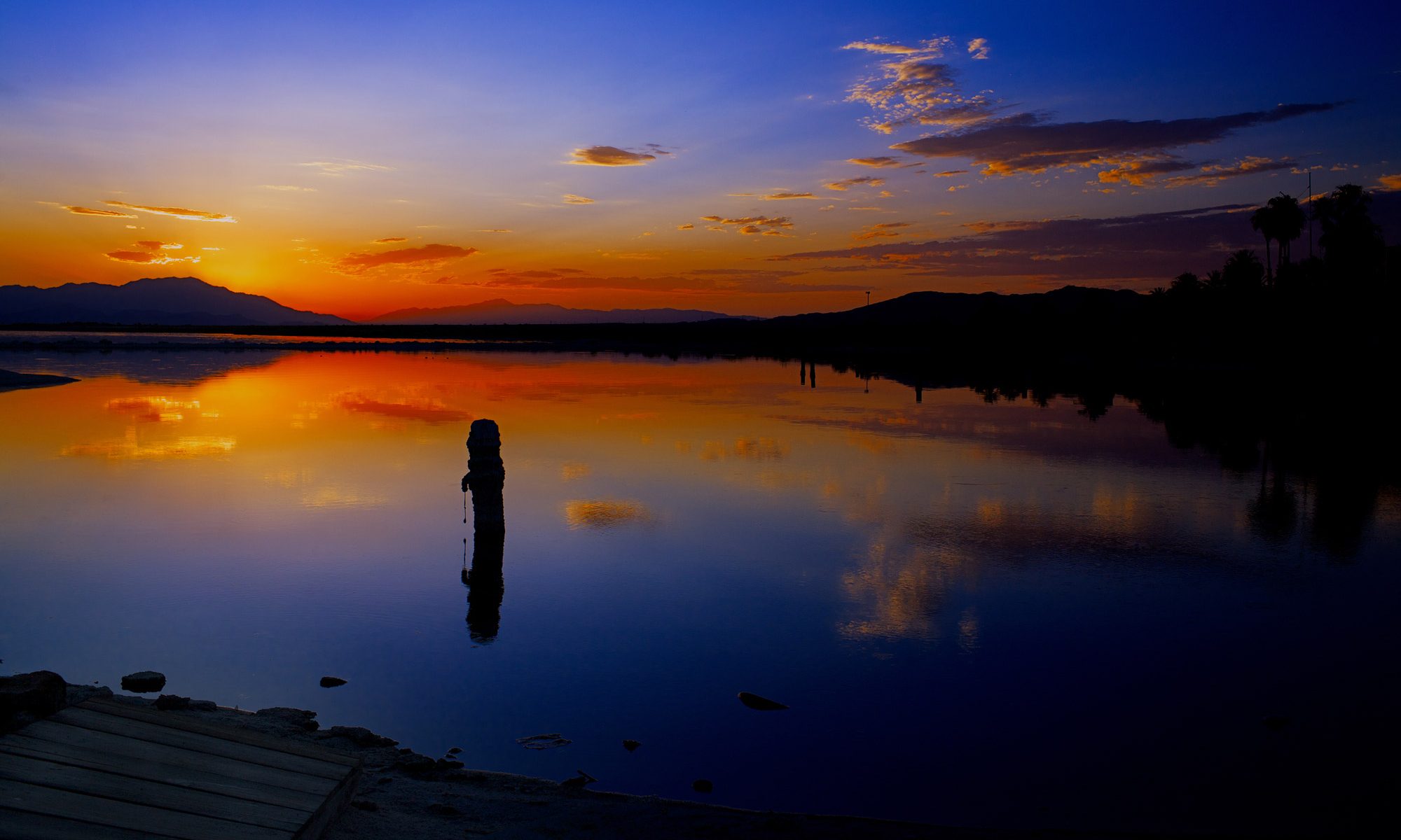
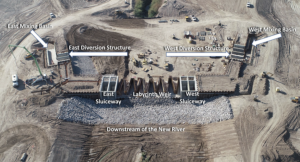
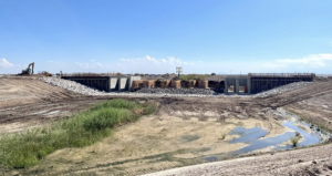
New River Diversion Structure Under Construction as Part of the Species Conservation Habitat Project
The New River diversion structure (star icon) is a major component of the Species Conservation Habitat Project. Completion of this feature signifies a major milestone for the project.
The Species Conservation Habitat (SCH) Project, spanning the New River at the southern end of the Salton Sea, will create a network of ponds and wetlands to provide important fish and bird habitat while suppressing dust emissions to improve regional air quality as the Salton Sea continues to recede. On schedule for completion in 2023, the 4,100-acre SCH is the first of many projects the Salton Sea Management Program (SSMP) team will implement as part of the SSMP Phase 1: 10-Year Plan.
The New River diversion structure is a major component of the overall SCH Project. It will allow water diversion into the habitat ponds. The East and West Sluiceways will allow the water coming from the New River to flow north into the Salton Sea. The Labyrinth weir will allow the New River water to rise and a portion of it will flow by gravity to the New River West and East Intake Structures. The mixing occurs between the weir and the sedimentation basins at the mixing basins. Saline water from the Salton Sea is pumped in from the Saline Pump Station located at the north end of the Causeway into the mixing basins. The mixed water (from the New River and from the Salton Sea) will then flow by gravity to the sedimentation basins and then to the habitat ponds. The New River diversion structure is also a flood control structure that will allow for water to go through without compromising the integrity of the project.
During the first phase of construction of the diversion structure, material placement and removal was completed for ground improvement. Then followed by excavation and embankment, installation of sheet piles, and the concrete and rebar installation for the weir structure. The New River Diversion Structure is anticipated to be completed by the end of 2022.
Construction of the SCH Project is expected to continue through the end of 2023.
A few weeks ago, SSMP partners fromAudubon Californiapublished a blog post that narrates their recent experience at the SCH Project site. “We were pleasantly surprised to find ourselves counting thousands upon thousands of Black-necked Stilts, Long-billed Curlews, Least and Western Sandpipers…”
Releases from Hoover Dam may be reduced, shrinking the amount of water flowing to Arizona, California. By Ian James – enewspaper
With the nation’s two largest reservoirs continuing to decline, federal officials announced plans Friday to revise their current rules for dealing with Colorado River shortages and pursue a new agreement to achieve larger reductions in water use throughout the Southwest.
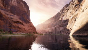
Colorado River
The Biden administration announcement represents a renewed push to scale back water use along a river that has shrunk significantly in the face of a 23-year megadrought worsened by global warming.
With water levels dropping at Lake Powell, the Interior Department said operators of Glen Canyon Dam may need to release less water, which would affect flows in the Grand Canyon and accelerate the decline of Lake Mead. In order to protect public health and safety and the integrity of the system, the department said releases from Hoover Dam may also need to be reduced — which would shrink the amounts of water flowing to California, Arizona and Mexico.
Federal officials in June called for the seven states that rely on the Colorado River to come up with plans to drastically reduce annual water diversions by about 15% to 25% regionwide. But negotiations among the states grew tense and acrimonious and didn’t produce a deal.
The Interior Department has the authority to step in and unilaterally impose larger cuts. But federal officials appear to be pushing for a consensus on shrinking the water take from the river rather than dictating reductions in ways that could further inflame tensions or lead to legal fights. This approach increases the pressure on the states to come up with a deal in the coming months or face federal intervention.
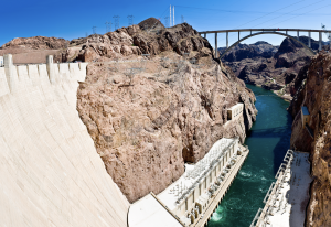
Hoover Dam
“The Interior Department continues to pursue a collaborative and consensus-based approach to addressing the drought crisis afflicting the West,” Interior Secretary Deb Haaland said in a news release. “At the same time, we are committed to taking prompt and decisive action necessary to protect the Colorado River System and all those who depend on it.”
Water from the Colorado River is used by about 40 million people, flowing to cities, farmlands and tribal nations from the Rocky Mountains to Southern California. The river has long been overallocated. So much water is diverted that the river’s delta in Mexico largely dried up decades ago.
Lake Mead and Lake Powell, the river’s two largest reservoirs, now sit nearly three-fourths empty. Declining water levels are putting the dams’ ability to generate hydropower at risk.
Without major cuts in water use, the latest projections show growing risks of the reservoirs approaching “dead pool” levels, where water would no longer pass downstream.
The current system for dealing with shortages was established in operating rules dating to 2007, and a 2019 deal laid out a series of additional cutbacks as Lake Mead’s level declines.
The federal Bureau of Reclamation said it will publish a notice to prepare a “supplemental environmental impact statement,” which will include alternatives for revising the 2007 rules. Those rules, called the interim guidelines, are set to expire after 2026, and negotiations on the next round of shortage-sharing rules have yet to begin.
The Interior Department said in this “expedited” review process, officials will consider revising the current rules to “provide additional alternatives and measures needed to address the likelihood of continued low-runoff conditions.”
The Bureau of Reclamation plans to analyze options including what it calls a consensus-based “framework” agreement that would build on water reductions that the states and tribes have previously agreed to.
Another alternative would be for the Interior secretary to exercise federal authority to change reservoir operations. The Interior Department said this alternative would also “consider how the secretary’s authority could complement a consensus-based alternative that may not sufficiently mitigate current and projected risks.”
The department said the review will also consider the “no action” option of staying with the current rules and agreements. The agency will accept public input through Dec. 20.
Reclamation Commissioner Camille Calimlim Touton said these steps are necessary “to protect the Colorado River System and stabilize rapidly declining reservoir storage elevations.”
Touton said these measures will better protect reservoir levels and water supplies while long-term plans are developed to address “the climate-driven realities facing the Colorado River Basin.”
BYJONATHAN J. COOPER, KATHLEEN RONAYNE- Los Angeles Times.
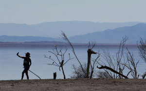
A visitor takes a selfie beside public art in Bombay Beach, a tiny community on the Salton Sea. U.S. Sen. Mark Kelly, an Arizona Democrat, wants the federal government to withhold money for environmental cleanup at the troubled lake until California agrees to use less of its share of Colorado River water. (Luis Sinco / Los Angeles Times)
California communities exposed to hazardous dust by a drying lake bed have found themselves at the center of tensions between Arizona and California over how to conserve water along the overtaxed Colorado River.
U.S. Sen. Mark Kelly, an Arizona Democrat facing reelection, wants the federal government to withhold money for environmental cleanup at the Salton Sea until California agrees to use less of its share of the river. He also faulted the U.S. Bureau of Reclamation for not being clear about when and how it will act if the seven Western states that rely on the river fail to significantly lower their use.
“We are out of time,” Kelly wrote Tuesday in a letter to the U.S. Department of the Interior. “The longer the Department waits to press for an agreement … the more difficult this crisis will be to solve, leading only to tougher choices and litigation.”
Federal officials in June said the states must dramatically cut usage as key reservoirs risk dropping so low they can’t produce hydropower or supply water users. But the states blew through an August deadline without a plan. Congress has dedicated up to $4 billion in part to pay farmers and cities to use less water, but its impact remains unclear.
Much attention is on California, the largest holder of the river’s water and the last to lose in times of shortage. The state’s users said recently they would cut use up to 9% contingent on federal money and a plan to clean up toxic dust around the Salton Sea.
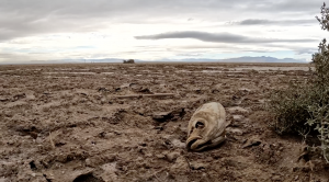
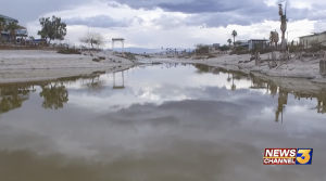
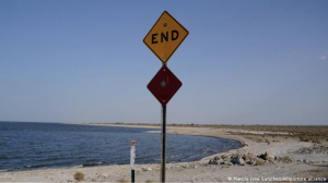
The Salton Sea, California’s most polluted inland lake, has lost a third of its water in the last 25 years. New research has determined a decline in Colorado River flow is the reason for that shrinking.
As the lake dries up, the concentration of salt and chemicals in the remaining water has increased dramatically, causing a mass die-off of fish and birds, including endangered species. The dry lakebed, coated in the salty, toxic water, becomes dust that causes respiratory problems for nearby residents.
“It is an environmental catastrophe,” said Juan S. Acero Triana, UCR hydrologist and lead author of a new study focused on understanding water movement on and below Earth’s surface near the Salton Sea, a research field called hydrology. The study was funded by the National Science Foundation’s Innovation at the Nexus of Food, Energy and Water Systems, or INFEWS, program.
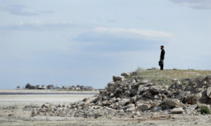
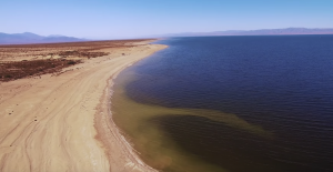
A view of the drying, shrinking Salton Sea and the playa left behind. (Stan Lim/UCR)
There have been a variety of hypotheses about why the water levels are steadily declining. Some blame climate change and heat for drying up the lake. Others suspect that agriculture could be to blame. As irrigation systems get more efficient and crops are modified to use less water, it means less water getting into the Salton Sea. However, the researchers say these are not the biggest causes of the sea’s decline.
“There is less water coming from the Colorado River into the Sea, and that is driving the problem,” said Hoori Ajami, UCR hydrologist, study co-author and principal investigator. This finding, and the methods used to obtain it, are now published in the journal Water Resources Research.
The researchers considered all major processes impacting the water balance of an endorheic lake like the Salton Sea, where water flows in but not out to any tributaries. Endorheic lakes worldwide have been shrinking in recent decades at what the researchers call an “alarming” rate due to the combined effects of global warming and diversion of water for agricultural and industrial purposes.
A view of the drying, shrinking Salton Sea and the playa left behind. (Stan Lim/UCR)
To understand the reasons for the Salton Sea’s decline, the researchers used a hydrologic model that accounted for all processes in the surrounding areas that impact the lake’s water balance, including climate, soil types, land slope, and plant growth.
Geographically the model included data not only about the Sea itself, but also from the surrounding watershed, streams entering the lake, and the land area that drains into those streams.
Data for the model was hard to come by as this is a transboundary basin on the US-Mexico border between California and Baja California Norte, and stakeholders may have been reluctant to share data that could alter previously earned water rights. However, using publicly available data and data mining techniques, UCR researchers were able to simulate long-term water balance dynamics and identify reduced Colorado River flows as the main cause of the Salton Sea shrinking.
“It’s not entirely clear, however, whether the decline in Colorado River water is more due to global warming drying out the river, or reductions in allocation levels to California, or both,” Acero Triana said.
Despite that lingering ambiguity, the researchers say the study should send a message to water management agencies and lawmakers that the Salton Sea watershed should be considered part of the Colorado River basin.
“Usually, the Sea is considered an independent system, and a watershed-centric approach considering surface and groundwater resources is needed to find a solution,” Ajami said. “As the environmental risks of a shrinking Sea mount, all parties must work together to mitigate the danger.”
Demands for its water far exceed what it ever could provide
MICHAEL HILTZIK
Hoover Dam – Luis Sinco LA TIMES
It’s human nature to mark big-number anniversaries, but there’s a centennial looming just ahead that Californians — and other Westerners — might not want to celebrate.
It’s the 100th anniversary of the Colorado River Compact, a seven-state agreement that was signed Nov. 24, 1922.
That evening, in the Ben Hur Room of Santa Fe’s Palace of the Governors, using the lapboard on which Gen. Lew Wallace had written his biblical epic 40 years earlier while serving as New Mexico’s territorial governor, representatives of six of the seven states of the Colorado River Basin applied their signatures to the compact with a gold pen.
The compact — essentially an interstate treaty — set the rules for apportioning the waters of the river. It was a crucial step in construction of Hoover Dam, which could not have been built without the states’ assent.
The compact stands as a landmark in the development of Los Angeles, San Diego, Denver, Phoenix and other Western metropolises. But it is also a symbol of the folly of unwarranted expectations.
That’s because the compact was built on a lie about the capacity of the Colorado River to serve the interests of the Western states — a lie that Westerners will be grappling with for decades to come.
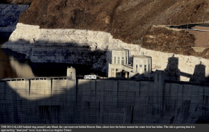
The crisis of water supply from the Colorado is vividly represented by the so-called bathtub ring around Lake Mead, the vast reservoir behind Hoover Dam, showing how far below normal the water level has fallen.
As my colleague Ian James has reported, federal projections show that the risk is growing that both Lake Mead and Lake Powell, the reservoir behind Glen Canyon Dam, are approaching “dead pool” levels, below which water would no longer pass downstream through the dams.
The prospect has led to pressure from the federal government on water agencies in California and the six other basin states to drastically cut back on water use. So far, however, no agreements on cutbacks have emerged.
The ultimate danger is that Lake Mead reaches the “dead pool” stage. At the end of last month, Lake Mead was at 1,044.28 feet of surface elevation above sea level. That’s about 100 feet below its level in August 2003 and about 180 feet below its record elevation of 1,225 feet, reached in July 1983. When the level falls to 950 feet, the lake can no longer generate hydroelectricity. At 895 feet, the dam can’t release water downstream.
The long-term decline in Lake Mead’s capacity has been blamed mostly on global warming. But as I’ve reported before, the river’s enemies are both natural and man-made. It’s true that nature has placed the basin in a long-term drought. But human demands for water from the Colorado have far outstripped what it can provide — indeed, what it ever could provide.
That brings us back to the compact negotiations. The impulse for a high dam on the lower Colorado came largely from California — principally from growers in the Imperial Valley. They depended on the river for irrigation and desired a more reliable supply as well as flood control that could only be provided by a major dam.
Congress resisted approving the project unless the seven basin states of California, Nevada, Arizona, New Mexico, Colorado, Utah and Wyoming could agree on how to apportion the river water among themselves.
The task of supervising the negotiations fell to Herbert Hoover, who was President Harding’s Commerce secretary.
The process was contentious. The upstream states were painfully aware that California was the most voracious user of the river’s water even though it had the smallest acreage within the basin.
All were convinced that California, the most-developed state of the seven, was plotting to appropriate more than its share of the water to stoke its continued development at their expense.
They were suspicious of Hoover, who though born in Iowa had made his home in California since becoming a member of the first graduating class at Stanford University in 1895.
Working with his deputy, Arthur Powell Davis — director of the U.S. Reclamation Bureau and a nephew of John Wesley Powell, the pioneering explorer of the Colorado and the Grand Canyon — Hoover overcame the states’ disagreements by promising that they all would receive enough water to provide for all their future economic growth.
They did this through connivance. Davis provided an estimate that the river’s annual volume averaged 16.4 million acre-feet. (One acre-foot, the equivalent of 325,851 gallons, is enough water to serve one or two average households today.)
That allowed the compact to be concluded with a guarantee that the upper basin states of Wyoming, Utah, Colorado and New Mexico could pass 7.5 million acre-feet a year — measured as 10-year averages of 75 million acre-feet — to the lower states of California, Nevada and Arizona without sacrificing their own needs. All the states agreed on this formula except Arizona, which didn’t sign the compact until 1944.
(By then the state had all but gone to war with California over water rights on the river, dispatching a squad of National Guard troops to the river on a ferryboat to block construction of Parker Dam in 1934. The ferry was derisively dubbed the “Arizona navy” by a Times correspondent assigned to cover the skirmish. After the federal government imposed a truce, the guardsmen were reported to have returned home from the “war zone” as “conquering heroes.”)
The real flaw in the compact was no joke, however: Davis’ figure was a flagrant overestimate — as he certainly knew, having studied the Colorado for decades.
The 1899-1921 time span on which his figure was based was one of the wettest periods in the basin’s known history. Indeed, only four times since construction of Hoover Dam began in 1931 has the 10-year average reached 16.4 million acre-feet.
Current estimates place the average annual volume of the Colorado since 1906 at 14.7 million acre-feet; since 1991, the annual average is closer to 13.5 million.
Yet the portions of California and the West dependent on the river for their sustenance have grown as if its bounty is effectively limitless.
In 1935, President Franklin Roosevelt dedicated the dam from a podium overlooking the project, declaring that it had turned the willful river into “a great national possession.” Since that time, the population of the seven basin states has grown by more than 52 million, much of the growth fueled by the water and electricity the dam has provided.
For several decades, however, climate and hydrological experts have warned that there can be no soft landing from the restrictions that global warming are forcing upon the Colorado River’s historical beneficiaries.
Hard choices are becoming imperative. The federal government is effectively ordering that the basin states cut their water usage by 2 million to 4 million acre-feet a year.
Talk of draining Lake Powell to keep water in Lake Mead at a serviceable level is getting louder, notwithstanding the political and engineering obstacles standing in the way. Within basin states, especially California, water scarcity is exacerbating conflicts among growers, residential users and environmentalists.
The draconian cutbacks signaled by the federal government have been made necessary by inadequate action in the recent past.
As water and climate expert Peter Gleick told James recently, “If we had cut water use in the Colorado River over the last two decades to what we now understand to be the actual levels of water availability, there would be more water in the reservoirs today. The crisis wouldn’t be nearly as bad.”
The reckoning may have been long in coming, but it was inevitable. As long ago as 1893, John Wesley Powell — the uncle of Arthur Powell Davis, who perpetrated the foundational lie allowing the construction of Hoover Dam — foresaw the basin’s destiny.
Attending an irrigation congress in Los Angeles at which the coming paradise of water-driven growth was being proclaimed, Powell stood to deliver a hard truth. “I tell you, gentlemen,” he said, “you are piling up a heritage of conflict and litigation over water rights, for there is not sufficient water to supply the land.”
He was driven from the hall by a chorus of catcalls and boos, but time has proved him right.
The Turbulent, Thrilling Saga of the Building of Hoover Dam
COLOSSUS
As breathtaking today as when it was completed, Hoover Dam ranks among America’s most awe-inspiring, if dubious, achievements.
This epic story of the dam—from conception to design to construction—by Pulitzer Prize-winning journalist and Los Angeles Times columnist Michael Hiltzik exposes the tremendous hardships and accomplishments of the men on the ground—and in the air—who built the dam and the demonic drive of Frank Crowe, the boss who pushed them beyond endurance.
It is a tale of the tremendous will exerted from start to finish, detailing the canny backroom dealings by Herbert Hoover and Franklin D. Roosevelt, the herculean engineering challenges Crowe faced, and the terrific union strikes by the men who daily fought to beat back the Colorado River.
Colossus tells an important part of the story of America’s struggle to pull itself out of the Great Depression by harnessing the power of its population and its natural resources.
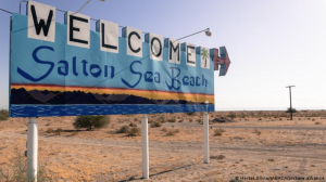
The Salton Sea is the biggest clean body of water in California. It is also the most toxic from agricultural runoff from the Imperial Valley and sewage flowing from Mexico into the New River which is then deposited into the sea. This scenario has been occurring for the last century and will continue unless an infrastructural change is made. I refer to the Salton Sea as the Chornobyl of California because of its toxic nature along with what has been displaced at the bottom of it. The Salton Sea was a test site for the Navy to test nuclear weapons and not all the contents of the testing, aircraft crashes, or airmen were retrieved. The severe drought poses a dangerous problem to the local constituents because of the toxicity of the playa that is exposed and constantly being blown over the southwestern part of the United States along with Northern Mexico. This causes respiratory complications along with different forms of cancer. The Salton Sea is along the Pacific Bird Highway and the exposed playa causes additional damage to the wildlife. Prospectively having a bigger negative impact on the western hemisphere of the world, distributed by migratory birds.
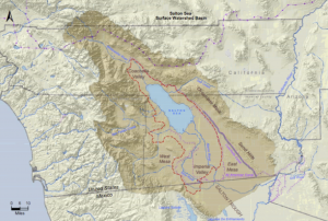
Salton Sea Area
The finding of white gold (lithium) hurts this scenario of faulty clean water infrastructure based on global demand and demand for progress within industries that utilize lithium. Plausibly rushing the mining process which could extend these problems way past their due date by complicating mining by not accurately and efficiently addressing these issues before mining starts. The Salton Sea is the biggest coagulation of lithium in the world which will influentially highlight our valley and our agriculture practices in a negative connotation.
This is where the solution I have been proposing on Twitter @Blake_S_Davis for the last 3 years comes into play. Hydroponics is the science of controlling every aspect of a plant’s environment to reduce stress which will increase quality along with the time of growth. Hydroponics conserves 90% of the water utilized in agriculture irrigation in the Imperial Valley traditionally defined as flood irrigation. Applying hydroponics to all crops but specifically forage crops should be the main goal for those who are being asked by the State Government to conserve clean water because of these inefficient water practices that have created this scenario of severe drought.
The short-term impact of hydroponics being applied at scale would replace 100% of the agricultural runoff with 90% more clean water flowing into the inlet of the Salton Sea. Which would put the Imperial Valley in a great position to renegotiate the delta of the New River efficaciously eliminating its existence in the United States. It would also free up the oppression occurring on the civil liberties of the local constituents while putting the Salton Sea in a better position to be revamped. This should be a collective goal that is seen as an achievable reality for the Imperial Valley.
Salton Sea
The long-term impact creates trust within the community by ensuring what is being done is in their best interest along with freeing up land mass for more economic opportunities. It creates an infrastructure that protects the local citizens’ civil liberties of one of the most valuable resources, clean water. Along with re-establishing the Salton Sea back to the tourist attraction it once was. Freight Farms are in 38 countries and 48 states and are doing research on my behalf to bring this idea to fruition along with cornering a specific part of the market that will not be forgotten about. “Freight Farms is the leader in the modular hydroponic farm market with a mission of creating a global infrastructure to revolutionize local access to fresh food.”
This solution was presented directly to J.B Hamby the director of the IID where it wasn’t given its due diligence because of the IID’s focus on protecting the commercial farmers of the Imperial Valley who have built empires through pollution and a lack of innovation from ignorance. I plan to directly compete with the product of all commercial farmers but initially and specifically those in the Imperial Valley.
The combination of commercial hydroponic forage crop farming and freight farms will position the Imperial Valley perfectly for the onset of the white gold boom that will occur within this next decade. My solution along with freight farms is the most viable and economically sound solution being introduced considering current export prices along with the importance of climate change via drought. For more information, please visit @Blake_S_Davis & @FreightFarms on Twitter.
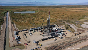
Three large mining projects based in California’s “Lithium Valley” aim to recover lithium with minimal environmental impacts. They have the potential to simplify the global lithium supply chain.
California’s rapidly shrinking lake is at the forefront of efforts to make the US a major global player in lithium production
About 200 miles (321 kilometers) east of Los Angeles lies the Salton Sea, California’s largest lake by area. It was once a recreation destination and home to a highly productive fishery, but in recent decades the lake has begun to dry up. Now the region has become famous for its most valuable mineral resource — lithium.
Until a decade ago, lithium was mainly used for glass and ceramic production. Now, roughly 70% of lithium is used for batteries. As electric vehicles continue to gain popularity, global lithium demand is skyrocketing.
Last year, US President Joe Biden signed an executive order requiring half of all new cars sold in the United States in 2030 to be zero-emission electric vehicles (EVs). This was seen as a bold step toward reducing carbon emissions, but critics point out that the US isn’t prepared to manufacture electric vehicles at that level. A critical limiting factor is that the US produces very little lithium domestically.
Similarly, the European Parliament approved a mandate that all new car sales need to be zero-emission EVs by 2035. But Europe also depends heavily on imports to meet its lithium demand.
Access to a steady supply of lithium is pivotal for the US’s and Europe’s e-mobility transition, which is why the Salton Sea’s mineral resources have suddenly gained attention.
Top lithium brine deposit
As the edges of the Salton Sea recede, pools of salty, lithium-rich brine are left below ground. In this way the death of the Salton Sea, which is being caused partly by drought conditions worsened by climate change, is becoming part of the solution for mitigating climate change.
Michael McKibben, a geochemist and research professor at University of California Riverside, leads a study analyzing lithium resources in the area.
“I’ve taken both a conservative approach and an optimistic approach to estimating the amount of lithium,” McKibben told DW. “It’s somewhere between 1 and 6 million metric tons of dissolved lithium metal in the brines.” (Or a lithium carbonate equivalent of 5 to 32 million metric tons.)
According to McKibben, that makes this area one of the top lithium brine deposits in the world.
Three companies are racing to tap into this immense lithium resource. If their projects succeed, they will establish a method for extracting lithium without the negative impacts of conventional lithium mining.
The three companies involved are Energy Source Minerals, Berkshire Hathaway Energy (BHE), and Controlled Thermal Resources (CTR). Energy Source Minerals appears to be the closest to their goal. They aim to collect battery-grade lithium at commercial scale by 2024. Berkshire Hathaway Energy has set 2026 as a goal for beginning commercial production. Controlled Thermal Resources has gained investment backing from General Motors.
Don’t call it mining
What sets these projects apart from conventional lithium mining is their connection to geothermal power plants, 11 of which are already established in the area. Geothermal plants pump up hot brine from underground and use the steam to generate electricity before re-injecting the brine back into the ground. Now they will add one more step — removing lithium from the brine before it’s re-injected.
“It’s important not to call it mining,” said McKibben, who prefers the term “lithium recovery,” because compared with conventional lithium mining, this process has minimal environmental impacts.
Conventionally, lithium is extracted in the form of hard rock, or from salts collected in solar ponds.
Hard rock lithium mining involves digging vast, open pits to pull out rocks like spodumene, which then need to be roasted and dissolved in acid. It’s a fossil fuel-intensive process, and has a devastating impact on the local environment. The vast majority of hard rock mines are in Australia, and to a lesser extent, China and Africa.
Salar pond mining involves pumping brine to the surface and leaving it in shallow pools. After the water evaporates, lithium-rich mineral salts remain. Salar ponds, also called salt evaporation ponds, take up thousands of square kilometers and deplete groundwater reserves, especially in desert regions where local populations depend on them. This method is most prevalent in Argentina, Chile and Bolivia.
Compared with salar ponds or hard rock mine pits, a geothermal power plant is relatively small, so direct lithium recovery projects require much less land use. The process avoids both the destruction and waste created by hard rock mining. It has a much smaller effect on groundwater sources than solar pond mining, because brine is re-injected into the ground after its use.
On-site battery production could simplify EV supply chain
In addition to lithium production, there are plans to build battery production factories nearby, which could change the EV battery supply chain on a global scale.
Today the vast majority of lithium is shipped to China to be refined. Refined lithium is then shipped to Japan for cathode production, and cathodes are shipped to the US for battery production.
By manufacturing batteries on-site, the carbon emissions from shipping lithium around the world are cut. Additionally, the US gains the strategic advantage of controlling part of the lithium supply chain, which could be of vital importance if conflicts between China and the US were to trigger sanctions.
Proponents of the project say that battery manufacturing plants would create thousands of jobs in a county that currently has an unemployment rate which is three times higher than the US average. Also, these projects will amount to significant income for the state of California, due to a recently approved tax on lithium production.
“We are very familiar with the developments in California,” said Horst Kreuter, CEO and founder of Vulcan Energy Resources. “Our technical director for lithium extraction was involved in lithium extraction in California in a leading role for over six years” he told DW.
Vulcan Energy aims to begin commercial production of lithium in Germany by 2024-2025.
If these projects prove successful, a path to cleaner lithium production may be just around the corner.
By Thomas Fudge / Science and Technology Reporter -kpbs
U.S. Bureau of Reclamation – This undated map of the Salton Sea basin shows the shape and size of a full Lake Cahuilla as indicated by the dotted red line.
Before the Colorado River was tamed by dams and dikes it was a free flowing, flooding river that often changed course, sometimes dramatically. Though it typically flowed south to the Gulf of California, in years of powerful floods it would flow into the Salton Sea Basin, and fill it up to form what we call Lake Cahuilla.
Since about 612 B.C. Lake Cahuilla has filled up seven times, the last time in 1733. The flooding Colorado would create a huge lake that stretched from what’s now Palm Springs, California in the north to well beyond Mexicali, Mexico in the south.
Thomas Rockwell is a geology professor at San Diego State who examined charcoal and other organic matter to determine when the lake filled and receded.
“Before we dammed up the Colorado River, the Colorado River would flood, seasonally. And during six of these periods in the last 1,100 years, the Colorado flowed, unabated, into the Salton trough, and filled Lake Cahuilla to an elevation of about 40 feet,” said Rockwell.
Rockwell adds that when it filled with Colorado River water the lake would be 100 meters deep at its deepest part and, as Rockwell says, it would have an elevation of 13 meters (40 feet) above sea level. It would dry up when the Coloradoresetits course toward the gulf of California.
The study sheds light on the human relationship with the land. Rockwell says archeological evidence shows how American Indian populations adapted to the changing lake.
“You had various Native American communities, the Cocopah, the Cahuilla, that would live along the shoreline and fish when the water was high. The Cahuilla are known historically to farm the bottomlands when the lake wasn’t there,” he said.
The Salton Sea Basin is at the southern end of the San Andreas Fault. Rockwell said his ulterior motive, as a geologist, was to study the history of earthquakes in the region.
“Now that we have this high resolution study of lakes, we’re putting together a high resolution study of earthquakes for the last 1,100 years,” Rockwell said. “Most of the earthquakes on the southern San Andreas fault occurred while the lake was full.”
He said the weight and the pressure of a full Lake Cahuilla would weaken the strength of an earthquake fault, making it more likely to fail.
The Salton Sea was created in 1905 when the Colorado River breached a dike and flooded part of the basin. What some view as a technical failure of flood control, Rockwell sees as a natural occurrence, given the history of Lake Cahuilla.
When asked what he thought of efforts to maintain the Salton Sea, which has been sustained through farm runoff, Rockwell said he understands the importance of the Salton Sea to migratory birds. But in its natural state, he said the Salton Sea would be entirely dry today.