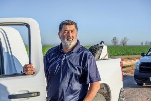
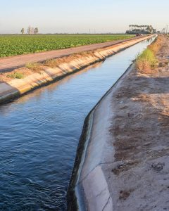
Lopez is a zanjero, or irrigation-ditch minder, in the Imperial Valley, an agricultural expanse that lies between the Salton Sea and the Mexican border. The Spanish word for “ditch” is zanja. Since the days of old Alta California, zanjeros have directed irrigation water where it’s needed, released exactly the right amount for crops to grow, and stopped the flow when the earth has had enough. California leads the nation in farm cash receipts—the Imperial Valley alone produced more than $2 billion in crops in 2019. Every farm in the valley needs water delivered by the Imperial Irrigation District. Lopez is their deliveryman.
When people think of the state and water, the so-called Kings of California often come up, like William Mulholland, a onetime zanjero who worked his way up to become the first supervisor of the Los Angeles Water Department and the builder of the Los Angeles Aqueduct. But who really controls the irrigation canals that carry water from the state’s reservoirs and aqueducts to the people and farms that are its end users? Zanjeros, the legendary water channelers of California.
With his salt-and-pepper hair and trimmed goatee, Lopez has the bearing of a college professor. And given the wisdom he’s earned by coaxing water out of rivers and over to thirsty fields, his patient and learned demeanor is itself an essential resource, especially during a drought. When he shares his story, you hear heritage, humility, and pride—a quiet confidence refined by decades of hard work on the canals. “My parents are from Sinaloa,” he says. “When they immigrated from Mexicali to the U.S., I was nine years old. My dad was a feed-truck driver. So [when] I was a little kid, I started working cattle. I used to work for a farmer in the valley. I’ve worked in agriculture all my life.”
In this valley, water is nature’s oxymoron: it exists because it shouldn’t. It’s piped in from the Colorado River, and the district employs 143 zanjeros to manage its path. In an average year in California, approximately 9.6 million acres are irrigated with roughly 34 million acre-feet of water. It’s an amount that would cover 31 million football fields with 1 foot of water. On the Imperial Valley’s football field, Lopez is quarterback, pass receiver, and sometimes coach, all at once.
Since the 1800s, zanjeros have guided the river’s edge, metaphorically and literally, first for the old Californio haciendas and later for the cities that replaced them. In Los Angeles’s early days, the zanjero was paid more than the mayor. For generations, zanjeros have navigated the back roads along canals, first on horseback and now in rigs with computers. More than the state’s land barons, more than the subjects of Hollywood mythologizing, zanjeros have wielded the power of necessity. Without the zanjero, there would be no California oranges or grapes. No California “backyard orchard.” There would be no California as we know it at all.
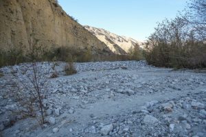
The Whitewater River, which normally flows year round in the Southern California canyon that bears its name, has run dry there, confounding some hikers expecting a brisk and scenic flow after recent heavy rains.
But those storms are the culprits, says Whitewater Preserve manager Lucas Wilgers, who oversees the area for the Wildlands Conservancy.
“It’s kind of counterintuitive … but when larger storms happen, so much water is falling such a short period of time, it just accumulates and kind of coalesces up above,” he said.
Fast-moving water carries mud, ash and other debris — including material from the 2020 Apple Fire burn scar — down from steep mountain slopesand dumps it at the stretch of river in the preserve, about 20 minutes northwest of Palm Springs in Whitewater Canyon.
Comparisons between the Salton Sea and Owens Lake have been made for years, and they’ve had a variety effect on residents and local officials.
Usually there is a healthy dose of fear, of the future, of the unknown, and what exactly is in store for Imperial County is the Salton Sea dries up.
Unfortunately, there is also a degree of apathy that comes with stories that sometimes feel like the tales of Chicken Little.
But what could become of the Valley is no fairy tale, and this is certainly not a case of someone yelling, “the sky is falling.”
For the first time we can remember, the Imperial Valley was privy to a scientific presentation on what happened to Owens Lake, how it compares to the depleting Salton Sea and what could — and will happen — to the local environment if measures aren’t taken to restore the sea.
Ted Schade, air pollution control district officer for the Great Basin Air Pollution Control District, gave a sobering and in some ways horrifying presentation on Owens Lake during Tuesday’s Imperial County Board of Supervisors meeting. (The PowerPoint of Schade’s presentation is available on our website.)
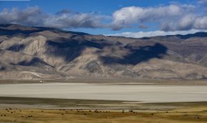
The short history of the lake is, the construction of the Los Angeles Aqueduct in 1913 pretty much drained the lake dry by the 1920s, and in the ensuing decades, the Great Basin was the site of dust storms and some of the highest-concentrations of PM-10 ever recorded in the United States.
Even today, with dust emissions controlled greatly, by 99 percent in some cases, using numerous methods, the Great Basin air shed still exceeds federal air pollution standards.
It’s debatable whether this scenario will repeat itself in Imperial County or whether there is the political will and revenue to bring the depleting Salton Sea under control before it’s too late. But it’s probably a fair guess that pollution around the Salton Sea will get worse before it gets better.
The demands of the water transfer that are already decreasing inflows into the sea are upon us, with a mechanism to fund and rehabilitate the Salton Sea still far from reality.
What that means is, locals have heavy lifting ahead of them and have to push hard to ramp up the efforts to restore the area before the dust storms of Owens Lake because a regular occurrence in northern Imperial County.
Schade’s presentation helped put the Salton Sea in perspective through Owens Lake, a presentation fueled with photos, statistics and dollar signs, which have far exceeded $1 billion at this point with more money due to be spent.
We hope this woke up people around the Valley to understand the long-spoken comparisons are not lip service but a future we might be able to avoid.
Can need for lithium cure what ails the Salton Sea
By Louis Sahagún
reporting from the salton sea
Studying the complexity of mud on the ocean floor is a life’s work for Timothy Lyons, so when the tall and lean biogeochemist asks you to join an expedition in search of chemical mysteries buried deep beneath the waves, be prepared to get wet and dirty.
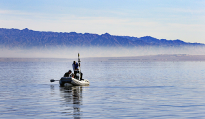
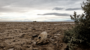
On a recent foray onto California’s largest and most troubled lake, Lyons rode a Zodiac skiff with a 15-horsepower engine across the Salton Sea against a backdrop of desolate mountains, dunes and miles of shoreline bristling with the bones of thousands of dead fish and birds.
As he approached the center of the lake with a clutch of passengers including two members of his laboratory at UC Riverside, Lyons said, “Cut the engine. Let’s grab some mud.”
Moments later, Caroline Hung, 24, and Charles Diamond, 36, dropped a coring device over the side, then hauled up a sample of sediment that was gray on the bottom, dark brown on top, and as gooey as peanut butter.
“The big problem at the Salton Sea is intermingled with that organic brown layer on top — and to be honest, it’s scary,” said Lyons, 63. “It’s loaded with pesticides and heavy metals — molybdenum, cadmium and selenium — that linger in greatest concentrations in deeper water.”
“That should worry people, because the Salton Sea is shrinking and exposing more and more of this stuff to scouring winds that carry them far and wide,” he added. “Our goals include mapping where these hazardous materials are located, and determining where they came from and what may become of them if trends continue.”
For Lyons’ research team, filling blanks in existing data is an obsession, and it could have significant implications at a time when the air practically crackles with a volatile mix of environmental danger and economic opportunities promised by ongoing efforts to tap immense reserves of lithium, a key ingredient of rechargeable batteries.
Few dispute the need for swift action at the 343-square-mile lake straddling Imperial and Riverside counties, about 150 miles southeast of Los Angeles. Clouds of salty, alkaline toxic dust containing heavy metals, agricultural chemicals and powdery-fine particulates linked to asthma, respiratory diseases and cancer are rolling off newly exposed playa, threatening the health of thousands of nearby residents.
Delays and costs are mounting for many projects that were designed to be showcases of restoration and dust mitigation. Scientists say it’s because the projects were developed without consideration for heat waves, severe droughts and water cutbacks due to climate change, or for the constantly evolving underlying geology at the hyper-saline landlocked lake at the southern end of the San Andreas Fault, where shifting tectonic plates bring molten material and hot geothermal brine closer to Earth’s surface.
Now, large corporations investing in proposals to suck lithium out of the brine produced by local geothermal operations have revived hopes of jobs and revenue from land leases, with lithium recovery projects potentially supporting internships, education programs and environmental restoration projects for years to come.
The big question during a recent meeting sponsored by the Lithium Valley Commission, a group of lawmakers and community leaders organized to help guide decisions that could affect low-income communities surrounding the Salton Sea, was this: What’s in it for us?
“The lithium rush at the Salton Sea cannot be stopped,” said Frank Ruiz, Audubon California’s program director for the lake and a member of the lithium commission. Communities surrounding the Salton Sea, he said, “see that as a victory — a ticket to a better life.”
“If done correctly,” he said, “it will elevate the region by creating jobs, benefit the state and the nation by making geothermal energy more affordable, and lay the groundwork for negotiations aimed at ensuring that some of the royalties from lithium production and related land leases are used to support dust reduction and environmental restoration projects.”
Jonathan Weisgall, a spokesman for Berkshire Hathaway Energy, which was recently awarded a $6-million California Energy Commission grant for a demonstration project at a geothermal facility in the nearby community of Calipatria, agreed, but stopped short of guarantees.
“My passion is workforce development and economic opportunities in the clean energy sector,” Weisgall said. “We don’t want to bring in a workforce from outside Imperial County if we don’t have to.”
The Salton Sea was created in 1905 when the Colorado River broke through a silt-laden canal and roared unimpeded for two years into a basin near Brawley then known as the Salton Sink.
Fishermen flocked to its barnacle-covered shores to catch corvina, croaker and sargo. Birds flocked to its wetlands, turning it into one of the most important stops along the Pacific Flyway for species including 90% of the migration’s white pelicans.
But the Salton Sea is a non-draining body of water — which is what makes it technically a sea and not a lake — with no ability to cleanse itself. Trapped in its waters are salt and selenium-laden agricultural runoff as well as heavy metals deposited over the last 116 years, authorities say.
Some scientists believed that 2018 would be the start of a profound environmental, public health and economic disaster for California.
The change was predicted in 2003 when the state Legislature promised to slow the shrinking of the lake as part of a successful effort to persuade the Imperial Irrigation District to sell some of its water to San Diego. Under the agreement, the district stopped sending fresh water into the lake on Dec. 31, 2017.
With relatively little water flowing in, the salinity level continues to rise. It is now at about 68 parts per thousand, authorities say. That’s nearly twice as high as the salinity of the Pacific Ocean, which is about 35 parts per thousand.
The Salton’s high salinity has made it inhospitable to tilapia, a primary food source for migrating birds; the fish has all but stopped reproducing. Visiting bird populations are a small fraction of what they once were.
The only fish in the Salton Sea today are inch-long desert pupfish and hybrid tilapia. Scientists say even these will survive only near the mouths of rivers and canals once the salinity level reaches 70 parts per thousand, which is expected within the next few years.
A study by the U.S. Bureau of Reclamation concluded that doing nothing to keep the Salton Sea viable could end up requiring nearly $10 billion in mitigation projects.
Critics point to the U.S. Fish and Wildlife Service’s Red Hill Bay project on the Salton Sea as an example of what has not been accomplished. The restoration program was designed to create more than 500 acres of shallow marine habitat for migratory shorebirds at the sea’s southern end in Imperial County, using water from a nearby river and a 183,000-pound steel barge equipped with pumps anchored a mile offshore.
Six years of delays have added costs to the project’s original $5.3-million budget. But it may never cross the finish line because of a series of unforeseen problems that have cropped up as the Salton Sea recedes and the flows of its tributaries decline. For example, the Alamo River is no longer considered a source of water for the project because its flows have fallen below an inlet that was designed to guide water into the proposed marine habitat.
As of November, the Fish and Wildlife Service has spent roughly $1 million in grants and budget allocations on the project, federal officials said. A $3.3-million grant awarded by the California Wildlife Conservation Board to help complete the work requires that the Fish and Wildlife Service secure a 25-year lease agreement with the Imperial Irrigation District by Dec. 31, said Pam Bierce, a spokeswoman for the federal agency.
On top of that, a year ago the Imperial County Air Pollution Control District slapped the irrigation district, which owns the property, with an order to deal with dust emanating from the work site. The irrigation district responded with surface-roughening techniques that reduced dust by 90%.
“The Red Hill Bay project was a solution to a problem that existed 15 years ago,” said Tina Shields, water department manager at the irrigation district. “The design doesn’t work anymore because it is a dynamic place and conditions have changed.”
Beyond that, CalEnergy Resources Ltd., a subsidiary of Berkshire Hathaway Energy, has a preexisting lease for the entire surface area of the project.
In a recent response to questions from Rep. Raul Ruiz (D-Coachella), the irrigation district said it “will work with CalEnergy to incorporate their plans for geothermal energy and lithium development on a commercial scale for the benefit of the local community and the rest of California.”
The Salton Sea remains an environmental war zone like no other. Lyons’ team aims to collect information that can help stakeholders make the best decisions moving forward.
His team members’ recent venture into the Salton Sea got off to a wobbly start when they gathered in bulging life vests at one of the few remaining places where a boat can be put into the water: a remote stretch of ankle-deep shallows and ooze.
After several minutes of pushing and pulling their little skiff into deeper water, they climbed aboard and set out on tea-colored water as smooth as glass. Their goal was 30 feet below the surface.
“It is an exciting time to be investigating the contents of the mud we’re pulling up out of the water,” Hung said. “In it are pieces of information that could help bring environmental justice to local communities.”
California, Arizona and Nevada are set to further cut back use
of Colorado River.
By Ian James
Two and a half years after signing a deal aimed at averting a damaging crisis along the Colorado River, water officials from California, Arizona and Nevada are discussing plans to take even less water from the shrinking river and leave it in Lake Mead in an effort to prevent the reservoir from falling to dangerously low levels.
Representatives of water agencies from the three states said they are firming up the details of a deal that would leave an additional 500,000 acre-feet of water in the reservoir next year, and the same amount again in 2023 — about double the quantity of water used annually by Las Vegas and the rest of southern Nevada.
For California, the deal would mean participating in water reductions prior to Lake Mead reaching levels that would otherwise trigger mandatory cuts.
The talks took on urgency this summer after federal projections showed growing risks of Lake Mead falling to critically low levels, despite plans for mandatory cutbacks throughout the Southwest that the states agreed to in 2019.
With the reservoir in a first-ever shortage and those cuts still insufficient, water management officials settled on a goal of together leaving half a million acre-feet of additional water in the reservoir instead of sending it flowing to farms, cities and tribal lands. The stored water would be roughly as much as 1.5 million average single-family households use in a year.
“We’ve got to stabilize the lake with this plan,” said Tom Buschatzke, director of the Arizona Department of Water Resources. He said representatives of California, Arizona and Nevada developed the framework of the deal within about two months after they saw projections showing growing risks of Lake Mead dropping to lows that would trigger much larger water reductions in all three states.
“I think coming together in that short a period of time is indicative of urgency we’re feeling to do more,” Buschatzke said. “If the lake keeps falling, cuts are going to be deeper and deeper and deeper. So I think it’s indicative of the risks.”
The deal would nearly double the reductions in planned water deliveries next year among the three states beyond those already planned under the 2019 agreement, called the Drought Contingency Plan. This new proposal, dubbed the 500+ Plan, would partially involve securing money to pay some water users to voluntarily relinquish water.
“We are estimating that we’ll need $100 million for those two years from the three states,” Buschatzke said. And while it’s unclear how much may be available from the federal government, Buschatzke and others said they hope to see a similar amount contributed from Washington, with funds available through the newly signed infrastructure legislation.
The water would come from various sources, including farmers who would be paid for leaving portions of their land dry, tribes that would contribute water supplies, and water agencies that would leave some water in Lake Mead instead of taking it out as planned.
Negotiations on the details are continuing, and officials from California and Arizona said they hope to have the overarching agreement ready to be signed next month at a conference in Las Vegas.
Arizona has pledged $40 million toward the deal. Board members of the Southern Nevada Water Authority are scheduled to consider approving up to $20 million in contributions this week.
If the details of the proposal come together as planned, 500,000 acre-feet of water over two years would mean water levels about 16 feet higher in Lake Mead.
The reservoir, the country’s largest, has declined to 34% of its capacity, the lowest point since it was filled in the 1930s with the construction of Hoover Dam.
For now, the talks have focused on lining up funds and water for two years. But Buschatzke said it’s intended to be a five-year plan, lasting until the current agreement expires at the end of 2026, by which time the states will need to have negotiated new rules for dealing with shortages.
If the winter were to bring heavy snow to the Rocky Mountains, it could still help ease the shortages. But the region’s water managers said they’ve decided to plan for more of the dismal runoff they’ve seen in the watershed during the past two years of extreme heat and parched conditions.
Bill Hasencamp, MWD’s manager of Colorado River resources, said if such extreme dryness persists for another year or two, then Mead could end up at such low levels that cuts would become “unmanageable.”
“By proactively taking the actions now, we can reduce the risk of hitting those levels and having to make these large, unpredictable cuts,” Hasencamp said. “It’s better to do it sooner than you need it, so you can have a little bit more control.”
Without such a plan, if nothing were done and the reservoir continued to drop, he said, then the whole region could be forced to deal with much larger cuts.
“Then it’s unmanageable. And it’s lawsuit time and fighting,” Hasencamp said. “So a much more collaborative approach has always been our preference. And we think now is the time to step up.”
Word of the proposal came as California water officials announced that statewide conservation efforts were “backsliding.” Although Gov. Gavin Newsom has urged state residents to voluntarily cut water use by 15%, urban areas statewide decreased water use just 3.9% in September compared to the same month a year ago. The reduction in water use was smaller than in August, when Californians used 5% less.
Buschatzke said officials from the three states have together identified 500,000 acre-feet of water that could be freed up in 2022 and 2023. He declined to give details, saying negotiations are continuing and those that contribute water could include farmers, tribes, cities and other entities.
“It’s basically paying people not to use water they’ve historically used,” he said, adding that participants would voluntarily and temporarily cede water in exchange for payments.
Such deals have been tried on a smaller scale in recent years. In California, MWD has scaled up a deal in which farmers in the Palo Verde Irrigation District are paid to leave a portion of their lands dry and fallow. In Arizona, the leaders of the Colorado River Indian Tribes have also been leaving some of their farmland dry in a similar deal.
“We’re going to look at mixing and matching water and money to come up with the plan that works,” Buschatzke said. “The key is getting the agreement down on paper in an enforceable way so that we know the conservation is going to occur in 2022.”
The Colorado River has long been chronically overallocated, with so much water diverted to supply farms and cities that its once-vast delta in Mexico has been largely transformed into a stretch of desert, with only a smattering of wetlands remaining. Most of the water that’s diverted — approximately 70% — is used for agriculture.
While a large portion of the water is likely to be purchased through the fallowing of farmland, participants in the talks said some water will also come from other sources, including urban agencies leaving water in Lake Mead instead of sending it through their aqueducts.
For example, California’s Imperial Irrigation District has been underusing its allotment in recent years. And that “underrun” of water then typically ends up going free-of-charge to MWD, which is the next entity in line in the priority system.
That unused water is projected to be about 95,000 acre-feet this year, and likely a similar amount next year, said J.B. Hamby, vice president of the IID board.
“All that water we don’t use or over-conserve in a year, instead of that going to Metropolitan, Metropolitan has agreed not to consume it and to leave it in the river, which is a huge plus,” Hamby said. “That’s kind of a major shift.”
Hamby said it’s encouraging that the three states have come up with the plan in just a few months.
Others agreed that the quick negotiations bode well for more collaboration in dealing with worsening shortages. Kathryn Sorensen, director of research for Arizona State University’s Kyl Center for Water Policy, said with Lake Mead at such low levels, the need for quick action is clear.
“If we get another bad year or two, you know, things look really dire. So I think the speed is commensurate with the nature and scale of the crisis,” Sorenson said.
When Buschatzke testified in a congressional hearing on the Colorado River last month, he noted that snowpack in the Colorado River Basin peaked at 89% of average this year, but runoff in the watershed was only 33% of average.
“This phenomenon is likely the result of the hotter and drier conditions caused by climate change,” Buschatzke said in his written testimony. “This trend is one that water managers must take into account as we plan for the future of the Colorado River.”
The options for immediate measures, Buschatzke told senators, include additional mandatory water cuts or voluntary conservation of more water in Lake Mead, and the talks among the states were focused on the voluntary path.
Since 2000, the Colorado River has been ravaged by a series of mostly dry years, which have been compounded by the heating of the planet with the burning of fossil fuels. In that time, the flow of the Colorado River has declined nearly 20% below the 20th century average.
Scientists have estimated that about half the decrease in runoff in the watershed since 2000 has been caused by unprecedented warming. And this heat-driven aridification is projected to significantly worsen as temperatures continue to climb.
Brad Udall, a water and climate scientist at Colorado State University, likened the water reductions under the existing deal to a parachute — one that is too small and being opened too close to the ground.
“This new plan gives us both a bigger parachute and we’re going to deploy it sooner,” Udall said. “So hopefully we can have a softer landing.”
Given the alarming declines in the river’s reservoirs, the flaw with the parachute analogy is that the end of the story would put the parachutist safely on the ground, Udall said. “We’re landing on the edge of a cliff, if you will. And there’s still further to fall. We need another parachute here.”
Hopefully that next parachute will be ready well before 2027, he said, when the existing rules expire, and the Southwest needs to have long-term plans in place for adapting to a hotter, drier watershed and a river that yields less water.
California, Arizona and Nevada are set to further cut back use of Colorado River.
“Federal scientist Chris Schoneman had an idea in 2010. He wanted to re-create the once brimming, biologically rich Red Hill Bay at the south end of California’s largest water body, the shrinking Salton Sea. Schoneman, project manager at the U.S. Fish and Wildlife Service’s nearby Sonny Bono Salton Sea National Wildlife Refuge, believed the bay could gain new life as shallow marine wetlands. Schoneman and many others believed the project also would serve as a beacon for other restoration efforts around the sea. He found a strong partner in the Imperial Irrigation District, which owns the bay land, and nearly $5 million in state and federal funds were obtained. Volunteer military veterans and federal crews built berms, nesting sites and other infrastructure to hold water and fish. But the water never arrived, and the project’s fate is now uncertain. It may now be dead. … ” Read more from the Desert Sun here:
Salton Sea habitat site at Red Hill Bay bulldozed by IID
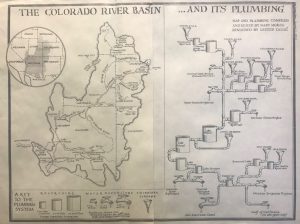
The Colorado River provides water to nearly 40 million people, flows through 9 National Parks, and drives a $1.4 trillion economy. If the Colorado River basin were a country, it would be the world’s 7th largest by economic output. But the river is stretched to its limit. Climate change and increasing water demand due to an expanding population is and will continue present significant challenges that if left unaddressed, will impact our regional and national economies, degrade the environment, challenge our agricultural heritage and food production, and limit recreational opportunities from fishing and boating to skiing. The Upper Colorado River Basin, defined by the river network above Lee’s Ferry in northern Arizona, is comprised of 4 states – Colorado, New Mexico, Utah and Wyoming. Collectively, the Upper Basin States contribute the vast majority of the water coming in to the Colorado River Basin, primarily through winter snowpack, but with the impacts of climate change altering the amount of snowpack and timing of spring runoff, water supply in the Colorado River is increasingly strained.
Once again, the chest beating for a sea-to-sea pipeline to “fix” the Salton Sea has begun. Here are a few facts are often ignored.
The Coachella Canal shows that it is possible to transport water long distances without pumping. That canal transports Colorado River water 122 miles to the Coachella Valley, all by gravity. It was completed in 1948, before current environmental regulations. According to the CVWD, this canal delivers about 280,000 acre-feet per year of water.
Assume a similar canal is used to transport sea water to the Salton Sea. It is estimated that the volume of the Salton Sea is 8 million acre-feet. The annual volume of the Coachella Canal is less than 4% of that. It is estimated that the New, Alamo and Whitewater rivers combined deliver 850,000 acre-feet a year of water to the Salton Sea. The Coachella Canal is only 33% of that volume.
Thus, you would need the equivalent of 3 Coachella Canals to equal the total flow of the three rivers, and that volume would not replenish the Salton Sea any more than the rivers do now.
Look at the chemistry of the water in the current lake. It is stated it is too salty to support robust aquatic life and too contaminated for humans to be around. Use the analogy of a swimming pool that is half full of bad water. A garden hose is run into the pool to start a refill. How much water will be needed to fill the pool and change the water to a quality you want? Simple answer is you can’t do it, unless you pump out the existing bad water and replace it with better water.
So, to improve the water quality and refill the Salton Sea, you will need two large sets of canals or pipelines: one to pump the too salty and contaminated lake water out and one to bring new sea water in. And you will need to continue doing this from now on.
All this imported sea water and exported unwanted Salton Sea water will be coming from and going to the ecologically sensitive Sea of Cortez. How many international environmental groups do you think are going to say that is a good idea?
It has been estimated that just a single pipeline to bring sea water to the Salton Sea would cost upwards of $10 billion, take international treaties and take decades to complete. If you had $10 billion to spare, how would you spend it? Would you spend it on better healthcare, social services, improved job opportunities and education for the people in California and that region, or would you spend it to refill a Lake by Mistake, so you can float a boat? This is not a trick question.
I have been working on a plan to create two smaller manageable lakes which would entail the Riverside County side to be fed by the Whitewater and Imperial County side to be fed by the New and Alamo Rivers.
A desalination facility powered using geothermal energy could be built/funded to mitigate the high salinity.
100 years of the Colorado river spilling water into Lake Cahuilla creating the Salton Sea, created a water table that could be pumped and added to the Sea to dilute its high levels of salt.
The EPA has a long used expression “the solution to pollution is dilution”
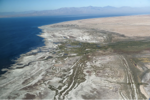
Time is running out to come up with a plan to save the Salton Sea. Water levels in California’s largest lake continue to drop, subjecting nearby communities to harmful levels of toxic dust stirred up from the dry, exposed lakebed.
For more than a century, the shallow lake has been a beneficiary of the Colorado River water that feeds the nearby Imperial Valley farm fields. As water was sold off and diverted, more than 15,000 acres of lakebed containing years of fertilizer and pesticide runoff were exposed to the air and desert winds.
The dwindling water supply increases the lake’s salinity, killing off fish, destroying once-lush migratory bird habitats and making children sick from the airborne toxins stirred up in the dust.
The California Natural Resources Agency was tasked with coming up with a long-term fix by the end of 2022, and 11 plans on the table focus mainly on one big idea: pulling in water across the U.S.-Mexican border from the Sea of Cortez north to the Salton Sea. Some proposals are more ambitious than others, envisioning tourism and shipping industries popping up along the desert canal.
Though full costs are unknown, fixing the Salton Sea arguably would be the biggest North American water project since the construction of the Hoover Dam in the 1930s.
What’s happening to the lake?
The modern Salton Sea – which has filled several times before – formed in 1905, when floodwaters from the Colorado River to the east breached an irrigation canal and dumped into a low-lying area called the Salton Sink, a depression in the desert that formed the lower basin of the ancient prehistoric Lake Cahuilla.
In the hundred years since the lake formed, it’s been sustained by agricultural runoff and became a rare stopover point for migratory birds traveling the Pacific Flyway.
As the Colorado River water has been transferred from the farms neighboring the lake to growing urban areas, the Salton Sea’s footprint has shrunk.